
Tools
Geostatistical Library (RIntaros)
The RIntaros package is a library developed to facilitate easy access to a set of geostatistical methods that partners needed in several services and applications in the INTAROS project. RIntaros relies on the extensive RGeostats package (http://cg.ensmp.fr/rgeostats), which includes a comprehensive collection of geostatistical procedures for R platform users.
RIntaros is used in several INTAROS services to interpolate in situ observations, which typically is scattered in space and time due to the high cost and/or limitations caused by harsh weather conditions in the Arctic. Figure 1 shows an example from a service where RIntaros was used to generate gridded fields of ocean temperature based on more than 20 years of CTD data.
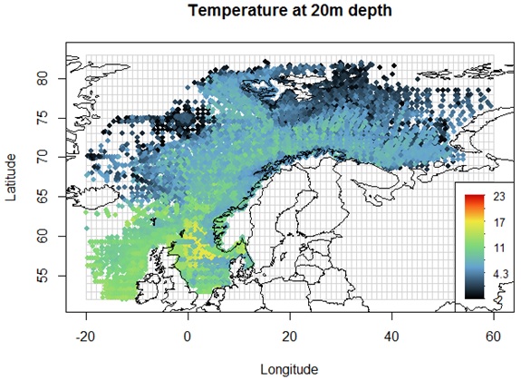
Figure 1. Temperature (°C) at 20m depth interpolated from more than 20 years of CTD data collected by research vessels operated by IMR (Renard et al., 2020).
Links to software:
- RIntaros packaging procedure: https://github.com/ec-intaros/r-rintaros
- RGeostats packaging procedures: https://github.com/ec-intaros/r-rgeostats
References:
Renard, D., Ors, F., Caumont, H. (2020). INTAROS Deliverable D5.6 Geostatistical Library v1.
Geostatistics package for satellite point data
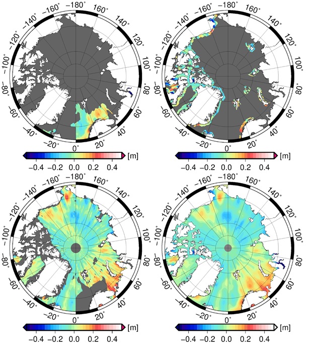
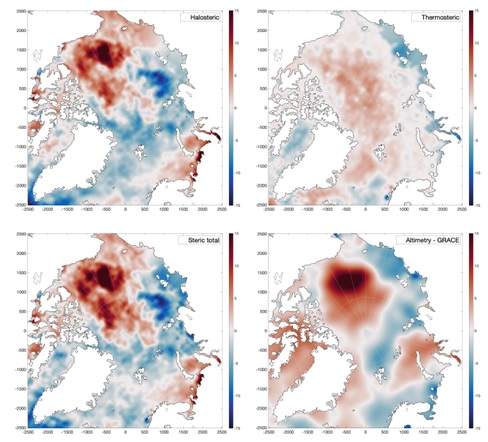
As part of INTAROS DTU has contributed to development an add-on R package for interpolation of satellite or ship observations, using Gaussian Markov random fields. This package is used to generate sea level products based on satellite altimetry data (Figure 2), resulting in gridded monthly halosteric and thermosteric sea level in the Arctic region from 1990-2018 (Ludwigsen and Andersen, 2021) as shown in Figure 3.
|
Figure 2. Gridded Sea surface height derived from Cryosat-2 (lower right picture). Data are merged from Cryosat-2 LRM observations (Upper Left) with Cryosat-2 SAR-in (Upper Right) and Cryosat-2 SAR (lower left) for July 2011. |
Figure 3. Interpolated grids of ship and satellite data. Halosteric (upper left), Thermosteric (upper right) and Total Steric (lower left) from ship observations and Total steric from satellite (lower right). |
Links to software:
- Software is available from DTU Space (contact O. Andersen (oa@space .dtu.dk)
References:
Ludwigsen, Carsten. A., Andersen, Ole B. (2021). Contributions to Arctic sea level from 2003 to 2015. Advances in Space Research, Volume 68, Issue 2, 2021, Pages 703-710, ISSN 0273-1177, https://doi.org/10.1016/j.asr.2019.12.027.
Resources
Some resources relevant for INTAROS are listed below (in alphabetical order).
Community Based Monitoring (CBM) and Citizen Science (CS) programs and initiatives
- Citizen seismology program, Qeqertalik, Greenland: https://raspberryshake.net/stationview/
- eBird: https://ebird.org/
- Exchange of Local Observations and Knowledge for the Arctic (ELOKA): https://eloka-arctic.org/
- GLOBE Observer: https://observer.globe.gov/
- Happywhale: https://happywhale.com/browse
- Pilot Whale Statistics, Faroe Islands: https://heimabeiti.fo/hagtol
- Piniarneq: https://www.qeqqata.gl/emner/borger/jagt_fangst_fiskeri/jagt_samlet
- PISUNA: http://www.pisuna.org/
- Raspberry Shake Community (seismic monitoring): https://raspberryshake.org/
- Spotter Pro: https://www.hi.is/rannsoknaseturhusavik
- Sea Ice for Walrus Outlook: https://www.facebook.com/seaiceforwalrus
- Yakutia CBM: https://mkp28.wixsite.com/cbm-best-practice/yakutia-cbm
Environmental monitoring programmes and initiatives
- Greenland Ecosystem Monitoring Programme https://g-e-m.dk/
- International Arctic Buoy Program (IABP): https://iabp.apl.uw.edu/
Research Infrastructures
- EPOS: https://www.epos-eu.org/
- Euro-Argo: https://www.euro-argo.eu/
- ICOS: https://www.icos-cp.eu/
- SIOS: https://sios-svalbard.org/
Arctic Data Systems
- Alaska Arctic Observatory & Knowledge Hub (AAOKH): https://eloka-arctic.org/sizonet/
- Bolin Centre of Climate Research database: https://bolin.su.se/data/
- CERSAT: http://cersat.ifremer.fr/
- Coriolis Global Data Assembly Centre (GDAC): http://www.coriolis.eu.org/Data-Products
- Global Runoff Data Centre; https://www.bafg.de/GRDC/EN/Home/homepage_node.html
- Greenland Ecosystem Monitoring Programme (GEM) database: http://data.g-e-m.dk/
- Nordicana D: www.cen.ulaval.ca/nordicanad/en_index.aspx
- Norwegian Marine Data Centre (NMDC): https://www.nmdc.no/
- NSF Arctic Data Centre: https://arcticdata.io/
- PANGAEA: https://www.pangaea.de/
- PISUNA database: https://eloka-arctic.org/pisuna-net/en
- Sea-Ice Portal of University Bremen: https://seaice.uni-bremen.de/
- SEANOE (Sea scientific open data publication): https://www.seanoe.org/
- SIMBA data repository, FMI: https://simba.srsl.com/fmi/ …
- World Data Centre for Greenhouse Gases (WDCGG): https://gaw.kishou.go.jp/
- Zenodo: https://zenodo.org/
Projects
- APPLICATE: https://applicate-h2020.eu/
- CAPARDUS: https://capardus.nersc.no/
- EU Polar Cluster: https://www.polarcluster.eu/
- INTERACT: https://eu-interact.org/
- Useful Arctic Knowledge (UAK): https://www.nersc.no/project/uak